UCS (User Coordinate System)

User Coordinate Systems (UCSs) are used for orientation, to define direction, to attach components in an Assembly operation, and many other operations.

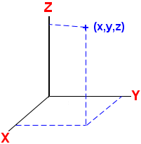
A UCS is displayed as three Cartesian axes (x,y,z) that are perpendicular to each other.

Every Cimatron file contains a default UCS; however, Cimatron also enables you to define your own UCSs and provides complete control over these UCSs using the UCS Manager.

The Global (or World) UCS is defined as being located at coordinates x = 0, y = 0, z = 0 (or 0,0,0, of the x,y,z axes).
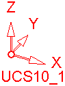
UCS Definition:
The relevant coordinates are of the form (x,y,z). The x,y,z spatial coordinates (coordinates of a point) can also be taken as the distances from the XY plane, YZ plane, and XZ plane. See the example below.

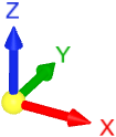
Cimatron Geometry UCS:
This UCS is displayed in a Cimatron file. Every Cimatron file contains a default UCS. Additional UCSs can be created and positioned as required.

See:
Geometry UCS Creation
Geometry UCS Manager

Cimatron Interactive UCS:
This UCS is displayed at the bottom-left corner of the Cimatron display area (when a file is open). This is used for easy control over rotation, orientation, and the direction arrow.

See:
Interactive UCS

See:

Interactive UCS

Geometry UCS Creation

Geometry UCS Manager

Some functionality may be dependent on the product package. Contact your Reseller if you require a license.